Thursday, February 28, 2019

Winter Travels 2019--Part 21: Moving to Lost Dutchman Mine State Park

Feb. 12-17: We left on Monday to drive about two hours north to the Phoenix area. Along the way we drove right by the Casa Grande National Monument and so we stopped to see it. The ruins of a four story, eleven-room, eleven-family building rise out of the desert floor, protected by a giant, steel “umbrella”. While its original use is still debated, it is the only four-story Native American ruin structure found in the United States and was built about 700 years ago. There are two small openings in the east and center rooms that are placed so the sun’s rays come through on the spring and fall equinoxes.  We watched a film, toured their museum on our own, and then had a very good ranger led guided hike of the ruins before getting back on the road. Archaeologists originally called the people the "Hohokum", which means people who have disappeared. The Native Americans now living in the area consider the term to be an insult; the people are their ancestors and they remain throughout the Southwest.
Our reservation was for the Lost Dutchman Mine State Park, which is extremely popular and just east of Mesa. It’s a convenient place to be and we have stayed there one other time so we’re pretty familiar with it. Our first campsite was in a new loop of non-electric sites and there was nothing behind us but the Superstition Mountains. It was a stunning site and we were sorry we could only have it until Friday.

Compound A is one of 8 Compounds in the area, and the only
one that has been excavated completely, and then partially
reburied to help preserve the structures that remain.

How it looked in the 1800s when Casa Grande was set aside to protect.

This is what remains of the tall structure called Casa Grande. It and the walls
around it have been partially reburied. The natives in the area have asked that
nothing be done to preserve it, feeling that their ancestors intended it to return
to the earth when it wasn't needed. Therefore, the roof is staying but no more
structural interventions are being done.

A pair of Great Horned Owls have lived at Casa Grande for a few years. The
female was out of site, in their nest on top of the protective roof. The male, seen here,
likes to hang out in the rafters of the roof. It was good to be able to see him. 

Looking inside where visitors are no longer allowed to go it's easy to see some of
the replastering that was done years ago to preserve Casa Grande. 

The rebars are being left in place but no further reinforcements will be done.

This shows the south west quadrant, where the level area hides
remains just below the surface. The bottom corner has walls for
another, smaller building.


The ancestors of the builders of Casa Grande built over
1000 miles of canals for irrigation, sometimes 10 feet deep
and 20 feet wide. Some are still used today, and all were built with
 stone age tools. It boggles the mind!

Winter Travels 2019--Part 20: Climbing Picacho Peak....almost

We made breakfast and packed a lunch on Sunday morning so we could hike the Sunset Vista trail, which goes along the west and south side of the peaks before joining the Hunter Trail, which goes to the top of Picacho Peak. We had no intention of making it to the Peak because it requires some skill and the ability to use cable hand holds attached to the rock face along the way. The first two miles of the Sunset Vista are listed as moderate, with lots of ups and downs through the washes that are dry at this time and a rise in elevation of about 800 feet. The last mile or so is switch backs climbing steeply with some cables before the junction. It was sunny and about 60° as we set out and only rose to the mid-60°s with a slight breeze, which was just about perfect. The first two miles took us to where the trail starts to rise steeply. We stopped there to enjoy our lunch and then I encouraged Marv to go ahead as far as he wanted; I was happy to sit in the sun and wait for him. He planned to hike 20 minutes more and figured it would take him about 10 minutes to return. Soon after he left, a couple from Canada came along and she thought my plan was brilliant and told “Dave” to go ahead and she’d wait for him. We chatted about our camping experiences. They left Calgary, Alberta on Dec. 26 and planned to stay until Feb. 28, but she was having second thoughts because of the cool, rainy weather. They are staying in a Teardrop Camper and have nowhere to be when it is cold in the evening. I spotted Marv 2 times along his climb and took a picture when he was way up there. When he returned, he had actually gone 25 minutes but had come to cables and decided to turn back, and his descent was slower than expected because of the steepness (it turned out that he was just yards short of the Hunter Trail). He went about .8 of a mile further than I but it was pretty rugged. I was glad I skipped it. Our return trip was also not much faster than our climb had been because of all the ups and downs. We got back and relaxed a bit as the sun lowered and the temperature dropped. Then we returned to the Sunset Vista parking lot for the sunset before grilling pork chops and warming broccoli and vegetarian baked beans for dinner. Although tired, we both got a nice hot shower before bed, which felt great.


Is this some kind of vetch? I never found out.

The bees love the Mexican poppies. They also were very active in the
yellow bloomed brittle bush, whose perfume filled the air throughout our travels.


Teddy Bear cholla in the sunlight.


Marv saw this little lizard when he went on without me.

The arrow shows approximately where Marv turned around on his climb.
This was taken from our picnic spot, where I waited for him.

Although we had seen Ocotillo blooms, this was the first we had
seen with the green leaves it gets with copious rainfall.

One of the many plants I couldn't get identified, Any hints would be welcome!


We look pretty happy, don't we?

The hills turn golden as the sun sets. This is looking northeast.....

....and this is looking southwest.


Tuesday, February 26, 2019

Winter Travels 2019--Part 19: First hikes at Picacho Peak

Saturday morning we hiked the easy .5 mile Nature Trail and then the .7 mile moderate Calloway Trail, which led to an overlook that allowed us to see a long way to both the south and north sides of the eroded Picacho Mountains. It was partly sunny when we began but mostly cloudy by the end. We got back just in time to move from B5 to B13, where we will stay for two nights. Then we drove back to the Trails to look at their “Memorial Trail”, with lots of information on the farthest west Civil War engagement, which took place at Picacho Peak! I showered and washed my hair in their good bathhouse. We have electricity and a good LTE signal here so I wanted to get some Journal posting done. When we move to Lost Dutchman Mine State Park, near Phoenix, we won’t have electricity and will try, for the first time, to go a week with only the solar panel to generate power.
The Mexican poppies and the Lupine were glorious, even
when the poppies closed with the cloud cover.

Even with a telescope lens the campground looked very far away to
the north from the saddleback ridge at the top of the Calloway Trail.

Marv loves to climb on the rocks!
Such a kid at heart.

You just can't get the perspective on how steep the trail was sometimes.

Looking south from the ridge, over the valley

Such intrepid hikers!

We climbed up to the ridge in the center, just to the
right of the highest peak in this picture. Picacho Peak(not shown), a
landmark for thousands of years, is to the right of this view.


One of the information signs about the Civil War in the Southwest


Winter Travels 2019--Part 18: Picacho Peak State Park

Feb. 8—11: I stayed in bed a little extra on Friday and Marv did most of the work to break camp. I made some tea and had a clementine and finally felt well enough to help finish up. As we left Gilbert Ray we drove past Saguaro National Park—West and stopped long enough to look at their exhibits, watch their video on the Native Tohono O’odham people and their relationship with the sacred Saguaros, and take a short interpretive hike with a Naturalist. Our next stay is at Picacho (pronounced like Picasso but with a ch on the third syllable) Peak State Park, about 40 minutes north of Tucson. Their brochure lists the Mexican poppies that bloom there as a seasonal “Point of Interest”, and we were thrilled to see them blooming in profusion as we drove to our campsite, along with Lupine. Our first site was a pull-through which made it really easy to get set-up. We ate lunch and then read in the sunshine but it only got to about 61°. My stomach was still aching but otherwise I felt much better. We rode our bikes around the three camping loops and drove to Sunset point to—obviously—watch the sun set, before grilling salmon for dinner. 
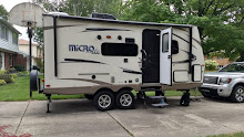
I thought you might be interested in how our trailer looks inside.
All day long the bed is raised and we have a couch
and lots of living space to enjoy.

At night, we fold the couch flat, and then lower the already made,
short-queen size bed to sleep. First thing in the morning, we make
the bed and fold it back up against the wall. Very handy!!

This was our first campsite at Picacho Peak, on the outside of the loop.


Marv got a good picture of the sliver of moon after the sun went down.

Monday, February 25, 2019

Winter Travels 2019--Part 17: Saguaro National Park East

I had an appointment at 10:00 on Thursday at U of A to get my infusion. We made it in good time and the infusion was done by 11:30. I’ve been getting the Simponi Aria for 6 months and never had an adverse reaction. So I was surprised that I felt worse and worse as the day went on. We went to Saguaro National Park-East and took a couple of hikes there and watched their film about the Park. On our way home we stopped at Costco to buy cheap ($2.09) gas and bought one of their roasted chickens. By the time we got back to the campsite I was achy and had chills, my stomach hurt, and my head hurt. I didn’t seem to have a fever but I really felt lousy. Marv made a big salad to go with the chicken but I couldn’t even finish my serving. We watched a couple of Northern Exposures and I crawled into bed. It was a very long night and I still felt lousy every time I woke up enough to assess.
Buckhorn Cholla

Chain Cholla

Coral Cholla

Teddy Bear Cholla
We also saw Pencil  Cholla but I guess we didn't get a picture. All are
also known as "jumping Cholla" because they attach so easily to passersby
they seem to "jump" onto anything they can. When removed, the small pieces
will then take root in the soil and grow a new plant.
Desert Ecology Trail at Saguaro East

Loved the big, many arm saguaro along the trail!

It's unusual to find 5 saguaros the same size right together.

Can you find the very large jackrabbit in this picture?


The Rincon Mountains are east of Tucson and Saguaro East
is nestled in their foothills.

Near the end of the loop drive through the park we stopped at a rock
formation called Javelina to climb on the rocks. That's Peggy and
our truck far below in the parking lot.

Climbing the Javelina rocks

Marv at a high point on the rocks