Monday, February 25, 2013

Out West Adventure: Part 1--Salton Sea and Agua Caliente

February 19-21: (Tuesday) Although it was windy when we woke up it wasn't stormy or even very cloudy. We closed up the camper and drove down to Hwy. 62 heading west. On the outskirts of town we stopped at the Hwy. 62 Diner for breakfast. Marv got the “Tire Patch” (pancakes, 2 eggs, & 4 pieces of bacon) and I got their waffle special (the same but with a waffle instead of pancakes). Either one would have been ample for us to share, and neither of us finished ours, but it sure was good! Back on the highway the clouds coming over the mountains and down the canyon were like a giant cotton batting. As we tried to get good photos out the window, the highway turned to the south and we plunged down a canyon, going from 2900ft to about sea level in a few miles. Coming out of the canyon at Desert Hot Springs there is a forest of wind turbines and the winds were buffeting the truck, probably at around 40 mph or more. Desert Hot Springs made a bell go off in my head because I’m sure that was where my dad was sent for Officer Training School before he shipped out to North Africa. Mom was with him until he shipped out. Since we weren’t in a huge hurry we decided to check out the area by following signs to a Historical Site and the Visitors Center, thinking it would be about General Patton and the army training area that we were told was there. It turned out that the Historical Site was about the hot spring baths that were in the area. A woman at the Center told us some roads we could take to get to a nearby military base but I don’t think she realized what we were seeking. But it was a nice drive along the base of hills and somewhat out of the wind until we got back on I10, this time heading east to the Salton Sea Recreation Area. On our way we talked to a guy at Agua Caliente Park and found out that they were expecting rain, not snow, but winds of 40mph and gusts as high as 75mph. As the ranger at Joshua Tree had told us that morning, “Sometimes discretion is the better part of valor”, and we were willing to give up the charge for that night to avoid the weather. We were driving across the Imperial Valley and passed field after field of green growing things, acres of date palms, and huge vineyards. All of this is in the midst of the Colorado Desert and therein lies the tale of how the Salton Sea came to be. In the late 1900s the government put in a canal to divert water from the Colorado River to the rich alluvial soil of the valley. But the farmers/ranchers weren't satisfied with the amount of water they were getting. So some of them went into Mexico and added two other canals that fed into the government canal. Then in 1905 there was bad flooding from snow melt and heavy rains. The three canals overflowed and merged and the entire Colorado River was diverted into the plain of the valley, where it ran for 16 months, eventually forming a lake 50 feet deep, 35 miles long, and as much as 15 miles wide, 230 feet below sea level, and right on the San Andreas fault line. It was originally a fresh water lake, but lack of outlet and tons of fertilizer runoff each year have slowly made it a saline sea about 50% more salty than the Pacific Ocean. It’s a fascinating story and somewhat eerie to see. In the fifties it was a highly sought after recreation area but the increasing salinity means that tilapia is about the only fish that still does well. Now there are many abandoned resorts and restaurants, reminders of what once was. We set up our camper in the “New Loop” of the recreation area, which is a circle with some sites with electricity and water, and some with no hook-ups. There are only a handful of sites taken. We rode our bikes up to the headquarters and visitor center and ate our lunch on the beach there, all by ourselves. Then we rode as far as the camp road goes and back, stopping briefly to see some displays along the way. There are other campgrounds in the recreation area but budget cutbacks have closed many of them and the whole area is looking a little neglected. After riding we changed into MSU gear and drove south for several miles to explore a little more. There really wasn't much to see but long stretches of gravelly shoreline. The lake is very important for migratory birds and there are several refuges along the shoreline. We saw egrets, white pelicans, killdeer, and lots of gulls. As it got later we turned around and headed back towards the cities to the north to find someplace to watch the big MSU/Indiana basketball game. We eventually settled in at an Applebee’s in La Quinta where we were disappointed to see MSU lose at home by 4 points, after being up 4 points with just over a minute left. There goes a #1 seed in the NCAA Tournament. L We drove back to the camper and talked to Marv’s Mom who had checked herself in to the Burcham Hills Rehab Unit until she feels stronger and better. We both enjoyed a hot shower before spending the rest of the evening on the computers.
Down into Imperial Valley with the cold front coming over the mountains
Cotton Batting Clouds

Wind Farm


White Pelican on the Salton Sea

The Salton Sea

(Wednesday) It rained a little bit early in the morning and with the clouds it only got into the mid-fifties overnight. We packed up the camper and, ignoring the GPS who wanted us to go north around the lake, we headed south the length of the Sea and eventually almost to Mexico to pick-up I8 towards San Diego. Along the way Marv was upset when he inadvertently reset our Trip odometer information. Within the last day or so he had told me we had driven 4100+ and had exactly 16mpg. We’ll have to extrapolate from that for the rest of the trip. All the way around the Sea we were below sea level. We got off at Ocotillo in the midst of a giant wind turbine area, where they were again placed on the east side of the mountains where the wind pours down the slopes. It was interesting to drive in the midst of the behemoths. We were again in the midst of the Colorado Desert, specifically the southern edge of the Anza Borrego State Park, which is the biggest state park in the nation. Around us was miles of desert land full of sotol, century plant, Cholla, and mostly, Ocotillo  which was just beginning to bloom. We drove north through the desolate park, seeing very few other cars and only a scattering of campers in the “dry” campgrounds. We went through some spectacular canyon lands and rose from below sea level to about 1300ft. as we arrived at Agua Caliente Regional Park, of the San Diego County Park system. There are hot springs here that have been visited and enjoyed by people for thousands of years. Now there is a campground with about 100 sites, and two outdoor spring fed pools that are a natural 90° and an indoor spa heated to 102° with Jacuzzi jets. When we checked in we were told that they had heavy rain and strong winds last night so we were just as happy that we had forfeited our first night and stayed at Salton Sea instead. After setting up we made lunch. As we ate Marv noticed some birds on the little tree next to the camper. Looking closer we realized that more than a dozen orange and bright blue birds (Western Blue Birds?) had gathered on the branches. They stayed long enough for us to get some pictures and then they all left, not to be seen the rest of the day. We walked around the campground and spent some time talking to a very friendly builder who was working on setting up the 7 cabins that will be available in a month or so to rent. Though the sun was shining brightly the air temperature was only about 59° so we chose to enjoy the indoor heated spa. There were about a dozen people in the large doughnut shaped pool which will hold 30 people. We struck up a conversation with the people who are camped several sites away from us (with no one in between), who had seen a TrailManor just like ours at their last campground. We chatted with them and then were joined by another man discussing camping, campers, and the freedom of being retired and traveling. The couple had been gone since Dec. 20 and was going to Patagonia Lake and Tucson before returning to their home in Colorado in a few months. The spa closed at 5:00 and by then the sun had disappeared over the mountains leaving long shadows on the rocks across the canyon from us. We went back to the camper to read and finish off the spaghetti sauce from the other night. Frogs were chirping like crazy in the narrow creek that runs through the campground and the stars were out competing with a very bright half moon. We have a good PBS signal but no 3G or phone so we worked on the Journal and watched a Northern Exposure before bed.
Anza-Borrego Desert State Park
GPS as we drove around the Salton Sea (-212 sea level)

Anza-Borrego Desert State Park

Campsite at Agua Caliente

Western Blue Bird in the tree next to the camper

Anza-Borrego Desert State Park

Blooming Ocotillo 

Anza-Borrego Desert State Park with blooming ocotillo
 (Thursday) It got down to about 44°, which we’re getting pretty used to now. The sun was shining brightly once again but the air was slow to warm. After eggs and toast and putting chili in the Crockpot to cook for dinner we decided we really had to be in touch with the family to see what was happening with Marv’s Mom. Since we had heard so much from the next door neighbors about Borrego Springs 45 miles north and the hiking trails and small village there we set off in the truck to find it. Much of the way we were driving through Anza Borrego Desert State Park lands and the scenery was spectacular once again. We climbed up to a pass near Box Canyon, where the Mormon Battalion had dug through the walls of a narrow gorge to make the first road passing through to the coast of California. Later it was used as the Butterfield Stage Coach route. We dropped down through the mountains and came out at the wide valley which contains Borrego Springs. The State Park is sort of doughnut shaped and the community of Borrego Springs is in the doughnut hole. We had phone service within the village so we called Mom and talked to her until someone came in to do her “intake” meeting. We drove on to the Anza Borrego Visitors Center. There we found out that the Desert is named for the Spanish explorer Anza, who came from Mexico in 1775-1776 leading 1000 colonists and, finding his way through passes for the first time, made his way up the coast where they founded San Francisco, and the big horn sheep known as Borregos that are indigenous to the mountains. Because it had taken us about 1½ to get there we were feeling a little pressed for time. So we stayed long enough to get some photos of a Century Plant that was blooming and then we set off for the hike to Palm Canyon. This 3 mile round trip trail took us up the canyon to a natural Palm Oasis. The trail was mostly wide and sandy and easy to walk until we got within about a quart of a mile, where it became much rockier and required some scrambling and creek crossing. It was sunny and in the high fifties at the beginning but the sun was soon blocked by clouds so it wasn't uncomfortably hot for climbing as it can often be. Along the way we saw lavender and jojoba blooming, the later alive with bees. We also saw rosa-something with its red honeysuckle-like blossom that attracted hummingbirds. We also saw a road runner on the trail but sadly, no borregos. As we arrived at the Oasis there was a bit of a jam up of people because a man had fallen and dislocated his shoulder. The group he was with was hurrying back down the trail to get help for him. So we didn't actually enter the Oasis but sat on the rocks beside it and enjoyed a little snack of string cheese and a Clementine before going back down the trail. We were passed by a Ranger and two paramedics going up to render aid. As we got back to the trailhead we found all of the Borrego Springs fire department and many Park personnel with emergency vehicles and walkie-talkies and a great hubbub. A helicopter arrived as we pulled away and we had to wonder what this rescue effort was going to cost! It made me happy that my ankle sprain had happened in the middle of a flat field within walking distance of the camper. We drove back into town and called Mom again to finish our conversation and went to a Mexican restaurant with WiFi for a 2:00 lunch. When we felt like we had done everything we could from so far away we drove back to the camper and arrived in time for a long soak in the hot spa. We also had another chance to learn more about the trails in the area from our neighbors, who are also leaving tomorrow. Marv made cornbread to go with the chili and after dinner we did the dishes and read and blogged as usual. 
Desert Valley near Borrego Springs 

Road Runner

Hummingbird

Trail to Palm Canyon Oasis

Blooming Century Plant

Happy Hikers

Palm Canyon Creek

near the oasis

Peggy crossing the creek

Palm Canyon Oasis

Wednesday, February 20, 2013

Out West Adventure: Part 1--Joshua Tree National Park

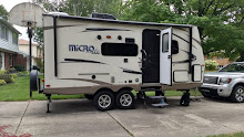
Feb. 16-18: (Saturday) We took down the camper this morning with an audience! Barb and Frank, the couple camped next to us from Montana, were intrigued with our TrailManor and wanted to see how it went down and packed up. She had been very solicitous of my injury and Marv’s Mom’s predicament, which she had overheard as Marv talked on the phone. They invited us to visit them on the second part of our adventure but then realized it will be while they are at Frank’s “homeland, The Netherlands, with their entire family. But we did exchange email addresses and then we were on our way. Before leaving the park we stopped at their little Nature Center/Gift Shop and then decided to try the short trail up to a lookout. I was pleased to find that my ankle with a brace on it could manage just fine. But my ribs were still really hurting. Highway 62 took us across the Colorado at Parker and into California and the Mojave Desert. The road stretched before us endlessly as we drove beside miles of an embankment lined with rock messages and names. We could see mountains around us in the distance on all sides but traveled through a flat valley pretty much the whole way to 29 Palms, where we came to the first Joshua Tree National Park Visitor Center. We stopped there to stamp our National Park Passport Book, get maps and information and eat our picnic lunch. From there we came across a Medical Center where we stopped to see if they had Urgent Care but they directed us down the road to a place in Yucca Valley. When we checked in there we were told that the X-Ray Technician wasn't there but would be on Sunday so we took the paper work and went on to Black Rock Canyon Campground. It was a good thing we had a reservation because all the Joshua Tree campgrounds are full on account of Presidents’ Day Weekend! We hadn't even thought about that. Many of the sites are occupied by tenters with lots of kids who seem to belong together in some way. They were pretty noisy when we pulled in in the late afternoon, but settled down as it got later and darker. Marv had picked out a nice drive-through site online that has no one camping across from us and is on the end of the loop so we only had the site on one side of us occupied. When they pulled in late in the evening and cranked up their generator we were a bit exasperated, but they turned it off earlier than required and didn't run it again until the next morning. Although we have no electricity or water at the site, and only cold water flush toilets, we found that we had a good enough phone and 3G signal to listen to the Spartans pull out a win over Nebraska and keep track of developments with Marv’s Mom, who was supposed to be released on Sunday. We’re at about 4000 feet but look straight down the canyon to Yucca Valley. It is much cooler up here but it’s a nice campground with a great view. As the sun set it cooled off quickly to the high forties but didn't get much lower. We had our leftover grilled chicken and played two games of Cribbage before bed.
Black Rock Canyon Campsite with Joshua Trees

(Sunday) It got down to the low forties but we had so many layers on that we were actually a bit too warm. As the sun came up and the coffee perked the camper warmed up nicely. Soon after turning off their generator our neighbors packed up and pulled away, apparently forfeiting their second night reservation; this was fine with us! We made French Toast and read the LSJ before making a picnic and going off to explore the interior of Joshua Tree National Park. Joshua Tree was made a National Monument in the 1930s and then a National Park in 1991. The two distinguishing features are the fantastical rock formations, which range from piles of huge, smooth boulders to what look like giant loaves of bread or rolls of cookie dough that someone has cut in fat slices, and the Dr. Seuss-like Joshua Trees, which are actually a yucca but have a rough barked main trunk like a deciduous tree. Their shallow root systems and need for water in the desert mean that the “forests” stretch on for acres of widely spaced trees no more than 30 feet high in most cases. They are as distinctive and unusual to us mid-westerners as the Saguaros of the Sonoran Desert. We returned to the Joshua Tree West entrance and drove in Park Boulevard to the southern terminus at Keys View. From the 5,185FT elevation we could overlook a stunning expanse of valley, mountain, and desert, including the San Andreas Fault running through the valley. There was a park ranger named Joshua present to answer questions and we asked him about our fears for the strong weather front that was forecast for Tuesday and into Wednesday, when we were supposed to be at Agua Caliente at about 4000ft. He agreed that it didn’t sound like that would work very well and suggested we go to the Salton Sea State Recreation Area, which we could see miles below us in the valley. The Sea is over 200ft below sea level and isn’t likely to see the winds and snow that we would have at Agua Caliente.  From Keys View we retraced our path back to Hidden Valley and drove to Barker Dam, where a ranger was leading a hike at 1:00. We put our picnic lunch into a back pack and first took the 2.2 mile hike to Wall Street Mill, a gold stamping mill from the 1930s until 1961. We took the wrong fork and ended up at the base of massive boulders with people climbing in some areas. But it was warm and sunny so we sat on the rocks and ate lunch. All we saw of the mill were a rusted out old truck and the remains of a dwelling but we felt like we needed to get back to join the ranger-led hike. When we got back to it, we realized that it was going to be full of Junior Rangers and really geared towards children so we set off on the 1.1 mile hike ahead of the ranger. There are interpretive signs and plenty of people so it was easy to follow. Barker Dam was built around 1900 to hold water for cattle and mining use, back when 10 inches of rain fell on average each year. Now the area gets 2-5 inches of rain and cattle ranches are no longer viable. There is supposed to be a small rain-fed reservoir behind the dam abounding in birds, but it was dry, dry, dry when we were there. We wondered if the forecast rain/snow will fill it this week. The walk was still interesting with some easy rock scrambling, lots of desert plants, and even some petroglyphs from nomadic Native Americans long ago. From that area we decided to do some sand/gravel back roads to get away from the crowds. We took Queen Valley Road to Big Horn Pass Road to Odele Road back to Queen Valley Road. The roads are so narrow that if one meets another vehicle, one of them needs to pull up the bank on the side to let the other go by! At the point to Queen Valley Road and Desert Queen Mine Road we took the short hike to the overlook for Desert Queen Mine. The mine was started in 1895 by Frank James (of the James Brothers). When he was shot along with Jesse, the cowboy who shot him took over the mine. It had many owners over the years and was closed in the 1960s. The mine shafts have been covered with grates by the Park Service to protect visitors but there are many artifacts left from the operations. It’s possible to hike down into the canyon to get a better look but we opted not to do so. Desert Queen Mine Road took us back to the east side of Park Boulevard and out of the park at the North Entrance Station. As we left the park and drove down to 29 Palms, the air temperature rose from 62° to 74° and our mileage was at 99.9+ as we coasted for several miles. We saw gas for $4.03, instead of the $4.35 we saw in Yucca Valley so we went ahead and filled the truck. Then we stopped for groceries before going back up the canyon to our campsite, where the temperatures were again in the low sixties. Marv called his mom, who was home from the hospital, and his Aunt Mary, to tell her what had happened. We added the leftover pork to baked beans and had that with salad. We did all the dishes and then watch some Northern Exposures before crawling gratefully into bed. It had been a good but tiring day!
Wall Street Mill Hike

San Andreas Fault running through the valley with Palm Springs at the base of the mountain

Cookie Roll or Loaf of Bread? You decide

In the shade of a Joshua Tree

Boulder piles against the blue, blue sky

(Monday) Happy Presidents’ Day!! This morning we were surrounded by people packing up their camps and we had the satisfaction of knowing we have another full day to explore this amazing park. However, my ribs were as bad as ever so we started the day with hot oatmeal, packing another picnic lunch and heading down to Avalon Urgent Care Center. Within an hour and a half I had been checked out and had 4 x-rays taken. The doctor said that 1) the ankle was a bad sprain but not broken (which I figured), 2) the “floaties” in my left eye probably had nothing to do with the fall, were perhaps because I’m not used to the dry air of the desert and should go away without treatment, and 3) my rib muscles were strained and inflamed but nothing seemed to be dislocated or broken. He faxed a prescription to a nearby Rite-Aid for a strong anti-inflammatory and said to apply ice and heat to both the ribs and the ankle and not to lift anything heavy for a while. By about 11:30 we had the pills and were on our way back to the park.  We went to Hidden Valley Campground just to walk around and see what other accommodations are available. Then we drove to the meeting place for our 1:00 ranger-led tour of the Keys Ranch, for which we had to register and pay ahead of time. We were half an hour early so we enjoyed our lunch while sitting in the warm sun but the temperature was only in the mid-fifties. The ranger, Joshua, met the small group and gave general instructions before unlocking the gate and having us drive a mile into the parking area. We then had a two hour, tightly held, somewhat slow presentation on Bill and Frances Keys and the ranch on which they managed to prosper and raise 4 kids from about 1920 until first Frances and then Bill (in 1960 at age 90) passed away and were buried on the ranch.  The ranch is pretty much as they left it, including the amazing amount of scavenged parts and building materials which Bill kept for his use and to sell to others through the years. There is a main house, many outbuildings, and a school house with a separate home for the school mar’m, several wells, a chicken coop, gold mining and stamping equipment, three dams, the list goes on and on! A park volunteer who lives on site was along for crowd control, I guess, and no one was allowed to wander around much. We couldn’t go in any buildings, partly for fear of the asbestos and the parvovirus from rodent droppings. Yosemite had a lot of trouble with parvovirus and some people even died so National Parks are being particularly careful now. We both really enjoyed the tour and were fascinated by this look at some rugged individualists who were willing to live out in the wilderness and make a go of it. After the ranch tour, Marv and I drove to a couple of spots for him to do some rock scrambling, which I passed on, not wanting to push the ankle TOO much. We took Park Boulevard down through Wilson Canyon approaching the wide, flat Pinto Valley, driving through the transition area between the high Mojave Desert and the lower Colorado Desert, which is a subsection of the Sonoran Desert. The difference in plants, with Cholla and ocotillo in the Colorado and yuccas and Joshua Trees in the Mojave, are obvious even to our uneducated eyes. At one point along the road the conditions are just perfect for Cholla and the park has a “Cholla Garden” walk with an informative brochure highlighting what we were seeing. The abundance of Teddy Bear, or Jumping, Cholla was just amazing and it was fascinating to walk the path. We made our way out of the park for the last time as the sun was setting and it gave everything a whole new rosy glow. As we drove into Black Rock Canyon a coyote trotted across the road in front of us. The campground, which had been full over the weekend, was nearly empty and we now shared our loop with only one other RV, halfway down the circle from us. It was getting dark at our campsite and as usual the temperature dropped quickly. Marv got things put away in the truck that were outside the camper to prepare to leave tomorrow while I put together leftovers with a can of Progresso soup to make a hearty stew for dinner. The wind was getting gusty and we were even more convinced that going to Salton Sea tomorrow would be a better choice than heading into mountains in the face of a winter storm.
Outbuildings on the Keys Ranch

Marvin on the Rocks

Low sun behind the Teddy Bear Cholla

Peggy itching to give the Teddy Bear a big hug

Cholla Cactus Garden

Marv climbing the rocks

Monday, February 18, 2013

Out West Adventure: Part 1-- Buckskin Mountain State Park

Feb. 13—16: (Wednesday) This was probably the worst day of our trip; certainly so far, hopefully for good. We took our time getting away from Superstition Mountain and reading all the coverage we could find about the wonderful basketball game the night before. Then we got on the road and headed a little north and west to the California border, stopping only once, to enjoy the pizza that Mary and Don had insisted we take. Most of the 180 mile drive was Sonoran Desert and very flat. As we got closer to our destination, we came upon fascinating black hills that seemed to be made entirely of bread loaf sized volcanic pieces unlike anything we’d ever seen. When we turned north to Parker, AZ we followed the Colorado River and were in the low, very rugged, red rocked Buckskin Mountains. Parker is on the Colorado River Tribes reservation and we made a quick stop for groceries before driving 11 miles to the state park. It is squeezed in on a point where the river turns about 90 degrees, among other resorts and RV parks on both the Arizona and California sides of the river, between two dams about 14 miles apart. The river is flowing here but it is wide and reservoir-like. As we pulled in to our campsite, we got a call from Ann Robertson saying that their mom, Thelma Hansen, had been in a minor car accident while she was driving, she wasn’t badly hurt, but she was at the hospital and Denny was with her. Once again we’re in a spot with very poor phone and hardly any 3G signal but we managed to talk to Denny and find out a little bit more, most importantly that their big concern was that her heart was acting up. He didn’t know much more at that point so we unhooked the camper and went for a walk along the park-like river bank. It’s very pretty and we were enjoying the 60° sunshine around 5:00. As we strolled in the grass, I missed seeing a recessed in-ground sprinkler head, badly twisted my ankle, and went down in a heap. After a few minutes of shock and moaning I decided I could hobble back to the camper. Marv grilled chicken and made most of our dinner while I iced my ankle, which he had wrapped in a make-shift bandage. I slowly decided that, while my ankle was probably sprained and not broken, as big a problem was that I had apparently cracked a rib or two. Eventually we drove into Parker, where we had been told there was a Redi-Care. But it turned out to be part of the hospital Emergency Room and they said they were extremely busy and it would be at least 2 hours. We opted not to wait and instead got some supplies at a CVS. After long phone calls with Denny and Ann, where we found out that the accident was her fault and they had Mom intubated and sedated with an external pacemaker to try and regulate her heartbeat we returned to the camper. We relearned Backgammon to kill some time as I iced my swollen ankle and then went to bed.
Buckskin Mountains

Changing Terrain 

Rugged, low rocks

(Thursday) HAPPY VALENTINES DAY!! After pancakes (I got a heart shaped pancake!) and making spaghetti sauce in the Crockpot for dinner, we managed to return Ann’s call from earlier this morning and learned a little more. She was now in Lansing at the hospital with their mom and was there when the entire team came in to discuss what was happening. They wanted to remove the pacemaker and wake her up to see how she would do on her own. Ann was contacting people and had found out there was a citation issued that will have to be paid in 10 days, but we’ll figure that out later. I have a bruise across my upper chest from the rib problem which hurts more than the ankle. I’m certainly not going to be able to do any hiking for a few days. But it was sunny and breezy and the temperature rose quickly from the high forties into the sixties so sitting outside, reading and writing seemed like a pleasant way to spend the morning. Indeed, it was how we spent the entire day. Marv made a tuna fish salad sandwich for us to share with veggies and half an apple for lunch. Afterwards we went down on the river bank to read in the sun. As we arrived the wind sprang up and gradually got gustier and gustier. But we had discovered that we had a WiFi connection, apparently from the resort across the river, and a better phone connection so we stayed for several hours. Occasionally we heard the braying of donkeys, which we thought must live at the resort across from us. When we got too cool, we moved up by the restroom, which broke the wind for us a bit. Marv talked to Ann again and learned that Mom’s system didn’t resume like they would have preferred so they left everything in place and will try again tomorrow. No one seemed concerned and, in fact, they thought she was doing very well and would have been surprised if she had recovered so soon. So Ann went back to Battle Creek for the night and will come back tomorrow and Saturday, at least. We finally moved back to the camper and sat in the sun, protected by the camper from the wind until we moved indoors and made dinner. We listened to Ella Fitzgerald sing love songs as we enjoyed our Valentine’s Day spaghetti dinner. We did all the dishes and watched some Northern Exposures before bed.

Valentine Heart Pancake
Icing and Reading

(Friday) It only got down to the fifties overnight, which was a nice change from the last week or so. It meant that right after our cereal we could go down to the river to sit in the sun and use the WiFi to read the Lansing State Journal as it warmed towards 70°. We also could read on Facebook that they had removed all the external support from Marv’s mom and she was doing much better. When we were finished reading I put a small pork roast in the Crockpot to cook for dinner and then we drove north to Parker Dam, behind which forms Lake Havasu. We drove across and stopped to see what we could of the dam, but, no doubt because of Homeland Security issues, you can’t see much nor can you do the tour which apparently used to be available. But we also found that the west (California) side of the river is a scenic byway, so we returned to the east side to have lunch at a Mexican restaurant we had been told was good and then returned “to California” to drive the 14 mile or so byway. All along the byway there were signs cautioning drivers to be careful to avoid the wild burros! So now we knew from where the braying was coming. And we saw quite a few peacefully munching on the hills beside the road. The byway is very picturesque and hugs the river the whole way. There are frequent pull offs to get pictures of both the river and the changing scenery along the west side of the road. At one point we were directly across from the State Park and could see our little camper. We saw red rock hills and brown cliffs and even two areas of sand dunes. We stopped at a Visitors Center which had closed at 2:00 but before we left we were hailed by the volunteer who runs it and lives on the property in a camper. He came with his lunch burrito in hand and insisted on opening the center and pretty much talked our ears off. He must not get much company! But he was knowledgeable about this area and about the places we’ll be going so we got some good information from him before a whole pontoon boat of partiers arrived to use the rest room and so he opened up again for them and we left. The whole day my ankle was feeling better and better and, although it is a rainbow colored balloon, I found I could walk pretty normally on it. My ribs, however, are another story; they seem to hurt more and more. We stopped at CVS to return one item we had bought and replaced it with an ankle brace which will do better now than the wrap we had on it. As we were leaving Parker and I had 3G I searched the internet a little and it sounds like I may have a dislocated rib or two, which would explain why it hurts to take a deep breath and the bump on my side. We’ll stop by the Emergency Room on our way out tomorrow and try to find out more then, if they’re not too busy. If they are, it sounds like it won’t do more harm not to fix it right away; I’ll just be uncomfortable a little longer. Back at the camper we finally got to talk to Marv’s mom and found out that her voice is trashed from the breathing tube but she is doing well. They plan on putting her in a regular room tomorrow to continue monitoring her and then think she can go home on Sunday! That will be a huge relief for us. The pork roast came out great for dinner, with lots of leftovers. At 6:30 we went to the giant campfire attended mostly by volunteers and a handful of regular campers like us. An accordion player entertained with lots of songs and a few guys told jokes/stories. We stayed until after 9:00 talking mostly to Lou and Joy, who have sold their house and 40 acres to their son and now live fulltime in their fifth wheel, volunteering at parks year round. It’s a fascinating life style, shared by many of the volunteers here, but I’m not sure I’d be able to give up having a “home” in one spot. Before bed we did dishes one more time and began packing up some things for our departure tomorrow to drive to Joshua Tree National Park.
Colorado River sand dunes

Colorado River sand dunes

Our campsite looking from the California side of the Colorado River

Wild burro

Down river from the Parker Dam

Parker Dam

Parker Dam from down river 

Out West Adventure: Part 1--Superstition Mountains

February 10-13: (Sunday) Today was an easy day of travel. We packed up and were on the road by mid-morning. Our route took us right past Casa Grande National Monument so we assumed we’d stop in to see it and get another Passport Stamp. However, there was a big Native American Music Festival today and everyone had to park across the highway and take a shuttle in to the park. It all seemed like too much of a production for us so we drove on to Lost Dutchman State Park, where we have a reservation for the next three nights. Once again our campsite is on the back of the farthest loop so the Superstition Mountains are the only thing behind our camper. Our loop has no electricity or water but it’s worth it for the view. And we can get by for several days with our battery if we give it a solar charge every day. After dropping off the camper (but not setting it up) we drove into Apache Junction to get some groceries, fill one propane tank, and mail Valentines to the grandkids. We returned later in the afternoon to set-up and I went to take a shower while Marv finished things up. The sunset was absolutely beautiful, reflecting off the mountains behind us. The temperature, which topped off about 61°, dropped quickly into the forties as we finished the Spanish Rice from the other night. It’s going to be a bit of a challenge to stay warm without the electric heater and electric blanket, but we do have a (very noisy) gas furnace that will help while we’re up and about. Lots of blankets and snuggling will hopefully get us through the night okay.
Superstition Mountains with the setting sun reflecting 

Our campsite

Sunset in Superstition Mountains
(Monday) It got down to the upper thirties overnight and clouds moved in by morning. There were low clouds on the mountains outside our windows, spilling down the canyon, and as we were eating our oatmeal it began to drizzle lightly. This seemed like a good day to do laundry again so we headed into a Laundromat where we could do everything at once and had WiFi to boot. Laundry while traveling has become a whole lot easier than the olden days! As we finished the sun was peeking through occasionally, but it was still only in the low forties and a light drizzle stopped and started several times. We made a couple other short stops and then drove back to the campground to have soup, cheese, and crackers for lunch as the sun seemed to come out in earnest. But as we finished, the rain began again. We read for a while and put away the laundry and by 3:00 the rain stopped for good and a weak sun came out to stay. So we took a 45 minutes hike on nearby trails where we found that the rain had caused many of the ocotillo to begin leafing out. We got ready to drive 45 minutes or so to Tryn and Chris Clark’s house in Tempe for dinner. (On the way there we heard that the high today was 16 degrees below average!) Their daughter, Vicky, lives with them with her two kids, Isaac and Aviva. Their other daughter, Tryn Rose, lives in Scottsdale so she came down to join us, too. We had a lovely evening and a delicious dinner and got all caught up on each other’s families since they left East Lansing and Edgewood Church many years ago. After lingering and chatting over dessert we regretfully left them but took with us a copy of Tryn Rose’s book on a therapy technique she has developed for working with people with Alzheimer’s. It was in the high thirties when we got back to the camper to read and play games until bedtime. 
Morning Fog

The last of the clouds

Saguaros in the Superstition Mountains

The mountains, all cleared off

Marv, Peggy,. Chris, Tryn, Aviva, Tryn Rose, Vicky 

(Tuesday) This was just a fantastic day from beginning to end!!!!! After the coldest night thus far we woke to a heavy frost outside and ice on the inside of the window by our heads. Clouds, steam, and fog boiled around the top of the mountains and the ascending sun shone through in rays. It was stunning. The furnace ran for a full hour to bring the temperature up, turned off for a few minutes, ran for a few more minutes, and then turned off for good as the sun managed to keep the interior of the camper around 70°. We enjoyed fried eggs then had enough signal to employ our Hot Spot sufficiently for us both to read the Lansing State Journal on our tablets. As I finished Marv made turkey wraps and a bag of veggies for lunch and then we did all the dishes. By then it was warm enough outside for us to take our hike into the mountains. Leaving out the back of our campsite, we took the Siphon Draw Trail to Prospector’s View Trail. The elevation rose about 800 ft. as we climbed and we were plenty warm despite temperatures in the forties. When we got to the high point above Green Boulder we sat on a big rock to eat our lunch. The sun was shining brightly without a cloud in the sky and the view up there was amazing; we could see the big buildings of Phoenix about 40 miles away in the distance. The mountains of Tonto National Forest to the east were dusted with snow from yesterday’s precipitation. Everything around us, including fresh new grass, was green and some of the jojoba shrubs were beginning to burst with yellow blossoms. It gave a very different look to the Sonoran Desert! As we ate, we noticed some people hiking way above us towards a rock formation called The Praying Hands. Refreshed from our lunch break, we decided to follow them for a while. So we set off on an unmarked, unnamed, undeveloped trail that was steep and rocky and rose another 300 ft. We had seen many people on the other trails. We met only the same people we had followed as they came back down and then two other people climbing as we descended. We ended up going farther than we had planned, up to the point where we had a full view of the Praying Hands and the trail began to wrap around the north side of the mountains. It was really pretty up there and much colder; the rocks and grass still had frost on them! We turned around and took the path back down, meeting up with the wide, well traveled, Treasure Loop trail and then taking Jacob’s Crosscut Trail back across to the Siphon Draw Trail and back to our campsite. The whole thing took us over 3 hours, with stops for plenty of pictures and videos, and we walked 4.14 miles altogether. We took a short rest for a beer while sitting in the warm sun with the temperature about 55°. Then we changed clothes and drove to Aunt Mary and Uncle Don’s in Gold Canyon. After chatting for a bit Marv and I walked with Aunt Mary to their huge “Clubhouse” to look around and get her mail. They wanted to take us to a favorite spot of theirs for dinner. Aunt Mary drove us to Mesa to Pipe Organ Pizza, where they have good pizza and an amazing theater organ that rises out of the center of the floor and then slowly swivels back and forth while the organist plays a short set of pieces using an astounding mix of stops to play every instrument you can imagine, mounted all over the huge hall. It was really enjoyable and we sat through two full sets as we ate our salads and pizza. When we got back to their trailer we checked to see if the MSU/um basketball game was over and were thrilled to find that it had just started. So we all had ice cream and watched #8 MSU completely annihilate the #4 (and past #1 ranked) team in the nation. As the announcer said, “It was wire to wire Sparty’s Party!” What a thrill!! Then Aunt Mary sent us home with a dozen fresh baked chocolate chip cookies and the rest of the pizza. Is that a great Aunt or What?!?! On the way back a small fox dashed across the road in front of us, the only real wildlife we had seen since Marv saw two little jack rabbits outside the camper in the morning. The camper was down to 40° but we got it warmed up to do a few things before we went to bed, tired but very happy with the day.
Trail Map

The Siphon Basin Trail

Another lunch with a view, high in the Superstition Mountains

Ascending the mountain trail

Frost on the rocks

Blooming Jojoba (I think?)

Dramatic sunrise

Praying hands formation

Peggy with Uncle Don