Fri. June 21: Summer
Solstice! We
spent the longest day of the year exploring North Cascades National Park. After
pancakes for breakfast and making wraps for lunch we drove west on Hwy. 20, the
Cascades Scenic Highway which was only completed in 1972. The road is lined
with wild flowers in bloom including lots of Indian Paintbrush and lupine. We
saw two deer along the way. From the campground at about 3000ft. we rose
steadily to go through Washington Pass at 5500ft and then Rainy Pass at 4800ft.
From there it was mostly downhill to the Visitors Center on the Skagit River at around 1000ft. Along the way we passed
many snowy peaks whose tops were shrouded in clouds, innumerable creeks and
cascades, and three Seattle hydroelectric dams with scenic reservoirs that were
put in well before the area was designated a National Park in 1968.
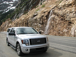.JPG) |
| On the road up to Washington Pass |
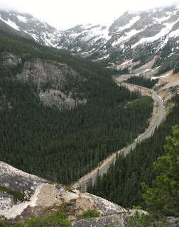
.JPG) |
| Diablo Lake overlook |
.JPG) |
| Gorge Creek as it joins the Skagit River |
.jpg) |
| Gorge Creek Falls |
We stopped
only a few times for pictures at falls and overlooks along the way and reached
the Visitors Center by noon. After getting our passport stamp and watching
their 22 minute video we chatted with a Ranger about what we should do with the
rest of our time in the park. She told us that we had passed the most beautiful
part of the park and didn't really need to go on to the west boundary. She
encouraged us to come back sometime when the weather was nicer to go to
Marblemount and take the Cascade River Road to the overlook at the end, saying
it’s the most beautiful parking lot in Washington, even if you don’t take any
of the trails there. But because it was partly cloudy and in the high fifties
she said it wasn't going to be worth our time this trip. Instead she suggested
we 1) return to Washington Pass and walk out the not-yet-open road to the
overlook and 2) drive out Cutthroat Road and hike to Cutthroat Lake. While we
were there, we took the 1.7 mile Skagit River Loop Trail through some old
growth forest. Even our inexperienced eyes could see a difference in the forest
on the west side of the Cascades from the forest where we’re camping on the
east side.
.JPG) |
| Impressive and colorful Shelf Fungus on a tree |
.JPG) |
| Add caption |
.JPG) |
| Skagit River bank |
.JPG) |
| Very furry tree! |
After that hike we drove a little further west and ate our picnic at
a raft launch area picnic table along the Skagit. As we drove east we made a
few stops, including at Thunder Knob, an arm of Diablo Lake, where we watched a
mama Barrow's Goldeneye Duck with her three adorable ducklings. The babies popped up
and down in the water just like little corks, while Mama kept a careful watch
over them. When Hwy. 20 crossed the Pacific Crest Trail we decided to hike a
little while on it. The trail went beside a small creek and into the forest
where we hiked over three small snow piles and then we turned back when we got
to a very large tree across the path.
 |
| Barrow's Goldeneye family |
.JPG) |
| Alpine lily along the Pacific Crest Trail |
.JPG) |
| "Hiking" the Pacific Crest Trail |
We proceeded back up to Washington Pass
and hiked about a mile up the closed and snow lined road to the short path that
took us to many spectacular views of the Early Winters River from its headwaters
down to the long valley in which we were camping.
.JPG) |
| Washington Pass overlook |
.jpg) |
| Highway and Early Winters Creek from Washington Pass overlook |
.JPG) |
| Almost clear view of a peak |
Finally we drove down the
valley to Cutthroat Road, a gravel road about a mile long and steeply uphill.
Our final hike of the day was the longest and most rigorous, but it was worth
it. The trail goes uphill, eventually getting back up into the snow line. There
were many trees across the trail that we had to climb over and farther up there
were small streams we had to hop rocks to cross, and some snow banks to walk
over. We passed a few groups coming back down along the way. The final pair
told us that we were almost to the lake and that they had taken the trail
nearly all the way up to Cutthroat Pass but had to turn back when the snow got
too deep. The lake itself was very picturesque and we had it to ourselves to
explore around the edges. It is a classic subalpine glacial lake tucked into
its cirque. As we walked around it we heard a loud crack and rumble from the
snowy peak behind it that could only have been a rock slide or an avalanche. When ready we
returned to the truck and found we were the only vehicle still in the parking
lot. It was after 7:00 by the time we got back to the campground. Chicken Chow
Mein tasted pretty good by the time it was ready, close to 8:00. We figured we
had hiked between 6 and 7 miles and had gotten a pretty good feel for the North
Cascades in our two days there but were sorry that, because of the clouds, we
never really got a good look at the panorama of snow-covered peaks and 300 glaciers for which it
is known.
.JPG) |
| Snow on the banks of Cutthroat Lake |
.JPG) |
| The rugged trail |
.JPG) |
| One of the "bridges" |
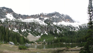.jpg) |
| Panorama of Cutthroat Lake |
.JPG) |
| Mountain Goat Marvin |
.JPG) |
| Another "bridge" |
.JPG)
.JPG)
.JPG)
.jpg)
.JPG)
.JPG)
.JPG)
.JPG)

.JPG)
.JPG)
.JPG)
.jpg)
.JPG)
.JPG)
.JPG)
.JPG)
.jpg)
.jpg)
.jpg)
.JPG)
.JPG)
No comments:
Post a Comment