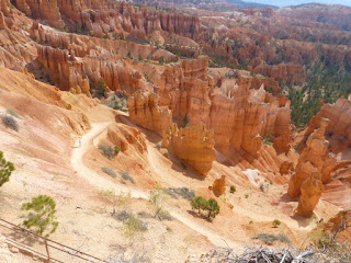
Mon. May 13: Monday dawned sunny and bright
and it quickly warmed, eventually to the low eighties. We broke camp and drove
over to Sunset View to take a hike down into the rock formations. By combining
parts of Rim Trail, Navaho Trail, and Queen’s Garden trail we could have a nice
nearly 3 mile hike before we left Bryce. The Navaho Trail descended steeply
with many switchbacks but we stopped often for pictures and taking in the
beauty. 350 feet down the trail levels off some and we wandered among the
formations and large butterscotch-smelling Ponderosa Pines. It was wonderful to
be at the base and look up at the hoodoos and beyond to the rim far over our
heads. There were lots of people on the trail speaking all the languages, some
doing the trails clockwise, which would have been harder. We exchanged taking
pictures with a man from Calais, France with very little English but he was
very pleasant and I managed to understand his mixture of French and English.
When we joined Queens’ Garden Trail (named for the hoodoo which looks very much
like the picture they had on a sign of a statue of Queen Victoria that is in
England) the trail gradually ascended back up to Sunset View. It is nearly as
high as where we joined Navaho Trail but, while still very strenuous, not as
steep as our descent had been. It felt very good to have completed the 2½ hour
hike and then set off for Capitol Reef.
.JPG) |
| Down, down, down...... |
.JPG) |
| Taken by our French buddy |
.JPG) |
| Queen Victoria riding (backwards) on a camel |
.JPG) |
| Yep, that's where we came from! |
.JPG) |
| Finished before lunch!! |
With a stop for lunch in Escalante for lunch at the Circle D café, where they smoke their own meats, it took us about 4 hours to drive to Torrey, Utah. Scenic Routes 12 and then 24 follow the route taken by Major Powell who surveyed and mapped this last uncharted part of the 48 continental states. The road took us up 9600 feet over Boulder Mountain, where there were many large patches of snow remaining. And then we descended into the Fremont Valley and the towering Capitol Reef.
“A giant buckle in Earth’s crust stretches across south-central Utah. This vast warping of rock, created 65 million years ago by the same great forces later uplifting the Colorado Plateau, is called the Waterpocket Fold. Capitol Reef National Park preserves the Fold and its eroded jumble of colorful cliffs, massive domes, soaring spires, stark monoliths, twisting canyons, and graceful arches.” (from the National Park brochure) It is the longest monocline on the Colorado Plateau. We found a campsite in a nearby RV Park and just dropped off the camper to have some time at the park. After stamping our passport and watching the video we purchased a CD to guide us on the three scenic drives at the Park. We took the longest first through the park to the end. The narrator guided us through the historic district along the Fremont River where pioneering Mormons established an orchard in conditions that allowed them to grow both northern fruits like apples, cherries and pears, and southern fruits like peaches and apricots. They also grew pecans and walnuts. The town was later named Fruita and though it had no more than 12 families at a time, they had a school and many orchards. We stopped at the original homestead that now serves as a small museum and store where I had a homemade strawberry sorbet and Marv had a personal size blackberry pie. Then the CD took us through the park to marvel at the formations along the reef. At the end of the drive we hiked about a mile up Capitol Gorge, far enough to see ancient petroglyphs and the Pioneer’s Registry, where passing pioneers as early as 1871 scratched their name and the date in the rock cliff of the gorge. The sun was setting by the time we returned to the camper, which we still had to set up. I managed to piece together a dinner from our dwindling staples and we both showered and got all ready to dry camp for a few days in the Moab Desert.
.JPG) |
| near Point Powell |
.JPG) |
| Point Powell |
.JPG) |
| Capitol Reef |
.JPG) |
| Scenic Road |
.JPG) |
| Ancient Petroglyph |
.JPG) |
| Capitol Gorge |
.JPG) |
| The Capitol, for which the area is named |
Sun. May 12: Happy Mothers Day! We had Cheerios
for breakfast and made a pretty quick getaway from Zion. We had been told by
two Rangers that we would need a special “one way” permit for $15 to go through
the narrow 1.25 mile tunnel to the east entrance of Zion. Built in the 1930s,
it isn't big enough for today’s campers and RVs. But the Ranger at the gate
assured us that he had been here for a long time and we were undersized—he didn't even measure us. So we were on our way. One climbs up, up, up (our
mileage dropped to 6.9mpg) to leave Zion through the east entrance and it is
amazing how different the scenery is after passing through the tunnel, which we
fit through without a problem. On the other side we made a couple of stops for
pictures, and we even got some of a small herd of desert bighorn sheep
browsing on the side of a mountain. We took a few pictures to compare to our
1976 pictures of the famous “Checkerboard” hillside. After climbing our way out
of the park, we descended for many miles and our mileage improved dramatically.
We drove in and out of the Dixie National Forest and passed amazing and
awe-inspiring scenery.
About lunchtime we arrived at
Bryce Canyon National Park. We had made a last minute decision to camp at Bryce
if we could instead of going to Capital Reef. Luckily there were plenty of
sites available and we even found a site in a loop that doesn’t allow
generators. (Or vehicles over 20 ft. We found out from a volunteer that we
probably didn’t qualify but because we could set-up and park the truck without
hanging in the road, he said he didn’t care if we stayed.) Our site, #100, was
really beautiful; up on the crest of a hill, we overlooked forest on two sides.
Like Zion, very few people are in the campground during the day. But Bryce is
very different from Zion in many ways. At Zion one looks up from the river
level at the canyon. At Bryce one is looking down from the rim at the fairyland
of formations that are in a natural amphitheater, not technically a canyon.
Zion is at about 3000ft. elevation and, at its highest point, Bryce is 9116ft.
elevation. It is cooler (it got down to 38° that night) and it is not as busy
as Zion. There was plenty of room in the campgrounds and not as many people in
general at the lookouts and stops. Bryce has a shuttle service but it only
started running in early May (their radio information said the shuttles weren’t
running yet) and it is voluntary. Like every place out here we felt like our
speaking English made us a minority. There is a huge mix of languages including
Italian, French, German, various Asian dialects, and only a little Spanish. As
usual most people seem to be our age; that may change when we get into June and
schools are out.
We set up quickly and then drove
to the Visitors Center to watch the film, stamp our passport, and get brochures
and trail guides. Only two shuttles a day go all the way to Rainbow View at the
end of the scenic drive. We could have made the afternoon shuttle but chose to
drive ourselves so we could stop as long as we wanted. Since all the views are to
the left (east) as you go south on the drive we followed the recommendation and
drove to the end without stopping. We passed a Utah Prairie Dog village and
several groups of antelope grazing along the roadside. After admiring the
amazing view at Rainbow we started hiking the short Bristle Cone Pine trail,
but then joined the trail to Yovimpa Point for another spectacular view that
had hardly any people. We slowly made the return drive, stopping at pretty much
every view point to marvel at the arches, bridges, windows, and hoodoos carved
in the varied colored sandstone. Several seemed to have resident ravens looking
for a handout and one was very cheeky, walking right up to me as I leaned on
the wall. There was a Ranger led hike along the Rim Trail that started at 5:00
that we hoped to join but we couldn't remember if it started at Sunrise or Sunset Points. We went to Sunrise and didn't find them, then went to Sunset and
still didn't find them. So we walked along the Rim Trail on our own reading
interpretive signs until we came upon the group and finished the walk with a
tiny, young, enthusiastic and very informative Volunteer Ranger. Along the way
we saw a beautiful Stellar Jay that seemed to be preening and posing for the
many people who gathered to take pictures. Since it was quite late when we
finished we bought a pint of Ben & Jerry’s ice cream at the general store
and took it back to the campsite to enjoy as an appetizer as we read and
relaxed back before we ate leftovers for dinner. We talked to Sarah for Mother’s
Day, went through pictures and went to bed as the temperature slipped down to
38°.
.JPG)
.JPG)
.JPG)
.JPG)
.JPG) |
| Quoth the Raven, "Where's some food?" |
.JPG)
.JPG)
.JPG)
.JPG)
.JPG)
.JPG)
.JPG)
.JPG)
.JPG)
.JPG)
.JPG)
.JPG)
.JPG)
.JPG)
.JPG)
.JPG)
.JPG)
.JPG)
.JPG)
.JPG)
.JPG)
.JPG)
.JPG)
.JPG)
.JPG)
.JPG)
.JPG)
.JPG)
.JPG)
.JPG)
.JPG)
No comments:
Post a Comment