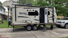


The truck was very happy as we drove east and then south on perfectly flat highways with speed limits of 60 miles per hour, and so we got around 17 mpg. During the 180 mile drive we happened to stop at the same park in Perry, FL to eat our picnic lunch where we ate last year. We arrived at O’Leno State Park, which is about in the middle of the peninsula, north of Ocala, by 3:00. We had the camper half set-up before we realized we were on the wrong site so we had to take down and set it up again next door. ARGH! We found out from our next door neighbor that there was a gathering of about 200 Indian Princesses at the park for the weekend. This could be interesting!
It got down to 42° during the night, but we stayed cozy with blankets and our comforter. By the time we enjoyed scrambled eggs for breakfast and packed a lunch in a backpack it was warming up nicely and there wasn’t a cloud in the brilliant blue sky. Most of Saturday was a comfortable 68°, perfect for hiking and biking. We rode our bikes to the day use area, where we learned history of the area. Originally named Keno (changed to Leno because of the gambling connotations and then Old Leno and finally O’Leno) there was once a booming town of 600 people with hotel, general store and several mills driven by the Santa Fe River. The Santa Fe runs for 44 miles to this spot, where it disappears underground for just over three miles, and then reappears for 35 miles before joining the Suwannee. The first Federal road through Florida once passed nearby and the town flourished until the railroad came and did NOT come through town. By 1896 there was no sign of the town or its people, who moved to other communities and took even the lumber from the buildings with them. During the Depression the CCC and the WPA built a suspension bridge and some buildings and people began visiting the site again. We hiked over 3½ miles of trails and rode our bikes 4½ miles as we explored the area. Much of it is the palmetto/long leaf pine/live oak vegetation with which we became familiar last year. We learned from “Bob”, an ancient looking volunteer in the Nature Center, that we could get the combination to get in the gate at the nearby “River Rise State Park” to see where the river reemerged from its underground passage. It was very peaceful and pretty there and we chatted with an old guy, his daughter and his two teenage grandkids who were fishing at the rise. The river is very low and both the sink and the rise show no sign of flow or turbulence or anything. If we hadn’t been told of the interesting geography we would have had no clue. That night we enjoyed a fire to help us stay warm as the temperatures took another nose dive under a canopy of stars.
Sunday turned out to be a very interesting day. We wanted to go to the Dudley Farm State Park, which was about 20 miles away. The historic farm was donated by 88 year old Myrtle Dudley, the last of 12 children of the only surviving son of the original founder. It has been returned to its 1890 state and is maintained as a working Cracker Farm. It was very interesting to wander around the old homestead, which is well back of the highway so one feels like one has stepped back in time. We walked a mile and a half there. We bought four giant grapefruits that were grown on the farm and shared one and had a cheese stick at 2:00. We decided that would hold us and then we would have an early dinner at the “Outdoor Café” in High Springs, near the park. Because two people within an hour of each other had recommended it, we decided to go on to Paynes Prairie State Park which was about 27 miles further, just southeast of Gainesville. The GPS had us get on I75 briefly but no sooner had we entered it then we came to a standstill. It took us about half an hour to crawl to the next exit and then we wound our way to Paynes Prairie. At the park we found out that there had been a terrible accident in smoke and fire about 5:00 in the morning on I75 that killed 10 people and so they had closed that part of I75. We also found out that the fire we had seen just outside the park gate was a wild fire turned bog fire that was not a ”prescribed burn”. They were controlling it and none of the trails was closed but we were going to be aware of it from the ash in the air and the smell. By the time we made our way to the Visitor Center it was 3:35. Right next to the path to the center there is a bald eagles nest with a nesting pair and we could clearly see one of the parents sitting next to the nest. The Center closed at 4:00 so we didn’t spend much time there and we didn’t take the time to watch their 20 minute video. Instead we took the circular one mile hike there to the edge of the prairie and saw a small herd of wild horses, descendents of the horses brought by the Spanish Conquistadors in the 1500s. Then we drove to the nearby Bolen Bluff trail and hiked 3.34 miles through a highland hammock of huge live oaks heavily laden with Spanish moss. Halfway back, at the edge of the bluff, the trail dropped down to the natural prairie and there is a sort of raised land dike that goes half a mile into the prairie with an observation deck looking over it. While on the dike we walked right among another small herd of the wild horses who continued grazing as we walked through. One white mare had what appeared to be a newborn foal nursing and yet none of them paid any attention to us. As we made our way back to the truck at twilight two deer bounded away through the trees. The freeway was still closed going south but we got back on it going north at the same exit from which we had exited and drove back to High Springs. The recommended Outdoor Café appeared to be very busy and we were pretty hungry by then so instead we went to the authentic High Springs Diner and had their Sunday special of Broasted Chicken. The four piece dinner left us with lunch for Monday! We were looking forward to having the campground to ourselves when we returned. And there were indeed only 4 campsites taken on our loop (other than volunteer/host sites) but to our dismay we saw that one of them was right next door in the closest spot to ours. L
After a 36° night, Monday was really a five star day. I made chili in the Crockpot (but not for tonight—for Ocala, when we won’t have electricity) and packed a lunch with our leftover chicken pieces while Marv loaded up the bikes, in hopes of taking the kayak to the Ichetucknee River, drop our bikes, and then kayak back to them. We drove the truck to the nearby Ichetucknee Springs State Park. The sign at the south entrance said that the park often closes for overcrowding. But it was clearly not a concern on a winter Monday as all entrances had no ranger and offered self-registration. But there was a ranger working outside there and when we told him our plans for the day he told us that we should put the kayak in at the tubing take-out site (closest to the river and only open in the winter) and paddle up the river because the current wasn’t too swift and then float back to the same spot. We drove to that gate and found one other vehicle parked, but it soon left. Because it was still cool we decided to bike the 4 mile round trip on the Tram Road (the only way to get to the river in the summer), eat our picnic and then kayak. At the mid-point dock we enjoyed watching a river otter on the bank across from us and saw one kayak go by from farther upstream. From there to Dampiers dock we took the nature trail along the river. After lunch we got the kayak ready and climbed in. A snowy egret was feeding as we left and an anhinga led us the whole way up the river. We heard the “hoo hoo hoo-hoo” of owls, screeches of hawks and, twice, incredibly loud drumming of a pileated woodpecker, which we saw the second time. The crystal clear spring water revealed schools of fish and waving grasses the entire length. We also saw many turtles sunning themselves on logs. We saw only one other person—a park employee in a kayak monitoring the river flow at Dampiers dock, where we chose to turn around. After having worked pretty hard to paddle up stream, the easy float back was a welcome respite. The wild and protected area, full of cypress trees and knees, Spanish moss, and towering oaks, was incredibly peaceful and lovely. Apparently in the summer one can practically walk across the river on tubers but today we had it to ourselves. Take-out was easily accomplished and we loaded up the truck and then drove to the north entrance to the park. The north and south areas of the park are connected only by the river; there are no roads or trails to get from one area to the other. There we hiked just over a mile to Head Spring, the beginning of the Ichetucknee River, and Blue Hole Spring, a tributary to the river which is also open to scuba divers who wish to explore the underground depths. We saw a couple of snorkelers but no scuba divers. Back at camp we found that our right hand neighbors had been replace by a left hand neighbor. One wonders why they put campers right next to one another when the entire loop had only two other campers?!?! We got most of our packing done for a quicker get-away in the morning and enjoyed leftover pork chops and beans for dinner.


